


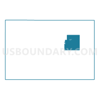
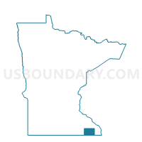
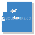
Holt Twp. Voting District, Fillmore County, Minnesota
About
Outline

Summary
| Unique Area Identifier | 601933 |
| Name | Holt Twp. Voting District |
| County | Fillmore County |
| State | Minnesota |
| Area (square miles) | 32.82 |
| Land Area (square miles) | 32.66 |
| Water Area (square miles) | 0.16 |
| % of Land Area | 99.52 |
| % of Water Area | 0.48 |
| Latitude of the Internal Point | 43.70172970 |
| Longtitude of the Internal Point | -91.89696400 |
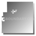
Maps

Graphs
Select a template below for downloading or customizing gragh for Holt Twp. Voting District, Fillmore County, Minnesota


Neighbors
Neighoring Voting District (by Name) Neighboring Voting District on the Map
- Amherst Twp. Voting District, Fillmore County, MN
- Arendahl Twp. Voting District, Fillmore County, MN
- Carrolton Twp. Voting District, Fillmore County, MN
- Lanesboro Voting District, Fillmore County, MN
- Norway Twp. Voting District, Fillmore County, MN
- Preble Twp. Voting District, Fillmore County, MN
- Preston Twp. Voting District, Fillmore County, MN
- Rushford Village Voting District, Fillmore County, MN
- Whalan Voting District, Fillmore County, MN
Top 10 Neighboring County Subdivision (by Population) Neighboring County Subdivision on the Map
- Rushford Village city, Fillmore County, MN (807)
- Lanesboro city, Fillmore County, MN (754)
- Amherst township, Fillmore County, MN (378)
- Preston township, Fillmore County, MN (359)
- Norway township, Fillmore County, MN (343)
- Arendahl township, Fillmore County, MN (337)
- Carrolton township, Fillmore County, MN (314)
- Holt township, Fillmore County, MN (271)
- Preble township, Fillmore County, MN (209)
- Whalan city, Fillmore County, MN (63)